Bluesky

AI Technologies to Extract Road Lane Markings from Aerial Imagery

Bluesky International (Bluesky), is a leading aerial survey and geographical data company; they produce and maintain high quality, accurate digital aerial photography and height data on a national scale in both Great Britain and the Republic of Ireland. Bluesky provides these geospatial data to public and private sector customers for a wide range of applications.

Challenge

Bluesky was looking to expand their product offering by utilising existing data collected from aerial drone images. The detection and classification of road lane markings from these images was of particular interest. Manual lane marking extraction is time-consuming and imprecise, requiring significant labour and causing delays in data processing. This highlights the need for a technological solution to streamline extraction, ensuring accuracy, efficiency, and timely decision-making.

bluesky screen shot

Approach

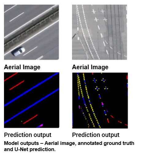
Bluesky has a national dataset of aerial imagery. Hartree Centre Northern Ireland Hub helped them explore machine learning and computer vision to extract lane markings from these images. We implemented an AI solution using computer vision and deep learning for automatic lane marking extraction. This AI, trained on labelled aerial images, provides a more accurate and efficient alternative to manual methods. Advanced algorithms analyse images, identify lane markings, and extract data points in real-time, enabling swift analysis of large datasets.

Benefits

The project demonstrated the power in using Computer Vision and Artificial Intelligence technologies within the aerial surveying business sector. Bluesky are empowered to use these technologies to extract additional value from data they already had to maximise value. Other benefits:

  • Bluesky expects to expand their market share and reach new customers in the future.
  • The automated process reduces the time and resources required for manual extraction, enabling faster data analysis.
  • The accuracy and precision of feature extraction was improved.
  • The automated solution offers scalability, allowing Bluesky to process a growing volume of aerial images without compromising on accuracy.
  • Bluesky are measuring the time and cost savings by automating the lane marking extraction process and expect that their AI investment will translate into long-term financial benefits.

Further information

This work was completed as one of our data projects. Our projects are up to 12 weeks in duration. We will work alongside your business to scope your project, demonstrate proof of concept, and explore options to deploy it within your business. If you would like to learn more about the Hartree NI Hub and our Programme, please get in touch with us at: info@hartreeni.uk

Our impact on UK industry and society

The Hartree National Centre for Digital Innovation enables businesses to acquire the skills, knowledge and technical capability required to adopt digital technologies like super computing, data analytics, artificial intelligence (AI) and quantum computing. The SME Engagement Hubs play a key role in offering targeted support for business challenges in their region, creating value and generating economical and societal impact for the UK.